The Scientist

I was just guessing at numbers and figures, Pulling your puzzles apart, Questions of science, science and progress, Do not speak as loud as my heart. -Coldplay

Tuesday, July 31, 2007

Fixin' the photo

Now, we all know that Bonnie is a very hard worker and quite busy most days with her research, however she took the time to touch up one of the photos from our Mount Robson hike. Bonnie didn't like that her eyes were closed in one of the pictures, so she 'fixed' it.
Here is the original:And here is Bonnie's version:It's actually not bad! It looks like her eyes are open. Let's zoom in, though, for a closer look:Zoom in more:Scary!! But we commend Bonnie for the effort she made. We'll just admire the above picture without zooming in and everything will be ok.

Monday, July 30, 2007

Mount Robson 4

We spent our last day in the mountains hiking out of them. In one day, we were to do the whole 21 km's that we had taken two days to climb on the way in. This may seem extreme, but it was all downhill, so we figured we could manage it. In addition, Garrett had hiked this same trail out in one day before without any problems. So, off we went, retracing our steps.The first segment of the hike was fairly fine, as it was quite flat overall. We stopped for a quick break and walked out to the Emperor Falls lookout, to see this spectactular waterfall:It truly was impressive. And wet!! The spray blew off the waterfall in a large radius, necessitating our raincoats. It's just too bad I can't share the sound of the waterfall with you as well!The hike downhill was actually a lot more difficult than we expected. Since it had rained the night before (big surprise), it was muddy and slick in a lot of places. We made our way at as fast a pace as we could manage, but sometimes it was tricky. As we went down, we were often impressed that we had, in fact, climbed UP this just the other day. It was so steep!

At one of our brief breaks down, Garrett took some pictures of me below Mount Robson. This was a little less than we saw of the mountain at other points on our trip, however we didn't manage to see the top of the mountain once over the four days we were there. It's too tall!This is looking back toward Emperor Falls.As we went down, down, down, we approached Kinney Lake again.We stopped for a brief break there before continuing on. By this point, we were getting pretty tired and sore, but we only had 7 km's left so we kept trucking. Here are a few picture of Kinney Lake:Awhile later, we reached the 4 km marker. So close, yet so far! The trail had widened and smoothed out, but those last 4 km's lasted so long! We were tired to so we stopped for another break, approximately 3 km's from the car:There were day hikers all along the trail, and we ran into an elderly couple hiking up for a view of Mount Robson. They saw us with our bags, poles and gators, and said 'Oh my, you sure came prepared.' I'm not sure if they thought we were carrying all that stuff for a day hike, or were just being silly...but still...

We were so excited when we finally got to the bridge (and thus, to the parking lot!). Hooray! Our hike was over and it was time to take off our hiking boots.

Monday, July 23, 2007

Mount Robson 3

Sorry for the delay, but here are the next set of photos from our hike in Mount Robson.

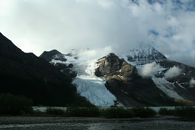
We woke up for our day hike at a reasonable time Saturday morning. We awoke to this beautiful view of the mountains and lake: We ate breakfast and set out on the trail up Toboggan falls, which was actually quite steep and a hefty climb. The falls were really neat because they had many different types of water falls and water flow throughout it's several hundred meter descent. 
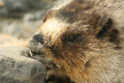
Halfway up, we came across this little critter:He was a little bit shy, but we waited for him to come out and snapped some good pictures of him. He was good at posing:
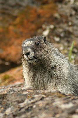
We postulated for most of the day as to what he actually was, since he was quite a bit larger than any marmots Garrett and I had seen before. However, later that evening one of the other hikers told us he is a hoary marmot. So, there you go, now we know.
Here are some more shots of Toboggan Falls:Near the top of the falls was the most impressive waterfall of Toboggan Falls, so we took some pictures there.We climbed up and up and up, until we were above the tree line. Our goal was a cave up at the top, which was recommended to us by Joelle and other hikers. 
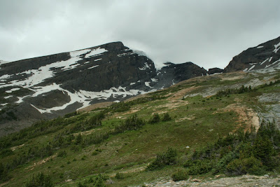
The view was quite impressive from up that high:
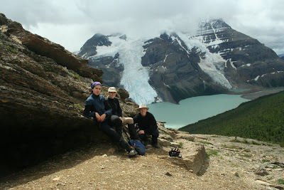
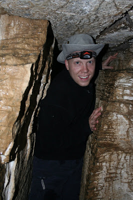
Here we are in front of the cave:
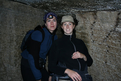
The cave was quite low to climb in to, but immediately the floor dropped away and it was high enough to stand up in easily. The main part of the cave went back about 30 meters, and was quite dark (we brought our headlamps) and really, really wet inside. The walls, roof and floor were all wet. We took some pictures inside, which turned out surprisingly well since we couldn't see where we were aiming when we took them.Halfway down the cave and off to the left was a narrow side passage that led into a string of three or four other rooms (I wouldn't know, since I was too scared to go all the way to the end. But Bonnie and Garrett went all the way in). Here is the passageway:
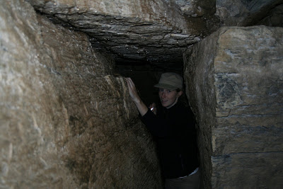
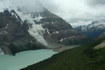
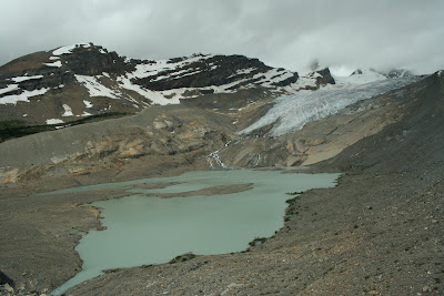
Looks scary, hey? In any case, it was really neat and even though I don't really care for caves, I really liked the experience. Afterwards we climbed up just a bit higher and took a photo of the Robson glacier, since we were just able to see it from where we were (it's just right of centre in the photo below):
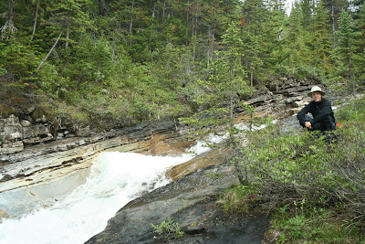
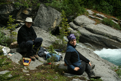
Next, we hiked all the way back down to the trail junction at the top of Toboggan Falls, which took surprisingly little time compared to hiking up it! We took the trail towards Halgreave Lake and stopped for lunch by a little stream:
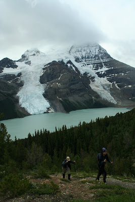
After lunch, we hiked along a relatively uneventful, although pretty, trail with lots of wildflowers and more of the same view of the moutains/glacier as I have already shown several times. Eventually the trail came to the lateral moraine of the Halgreave glacier. We climbed up the moraine to take a look at the glacier and its lake:It was a good looking glacier, with a really blue hue to it. At the top, we also saw more hoary marmots kicking around:
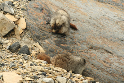
These guys weren't very scared of us at all, and were busy licking the rocks up there, presumably for salt, although we weren't really sure.
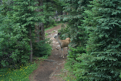
The hike down was steep but not terribly strenuous. We were back at camp around 3:30pm and relaxed and played some cards in the chalet, to pass the time. It was a fairly uneventful evening, although the weather turned fairly foul later on, so we didn't want to go outside. We did see this little guy wander into camp, though:We set the alarm for quite early the next day, since we had to hike out all 21km's in one day, rather than the two we took to hike in. Luckily it was downhill for the majority of the trail, but it was still a long distance, and after our hike we had to drive back to Edmonton still. So, early to bed, early to rise.

Mount Robson 2

We awoke to sunshine and mist, rendering the valley a puzzle of mountain pieces seen through the fog. Garrett took this beautiful photo from the campsite:And another photo, looking down the valley in the other direction.We packed up camp and filtered ourselves some water from the river, before heading out and up on our 10km hike.This is looking on top of the mountain and a neat little glacier hanging over the edge.Next, we started hiking up and up and up. We had about 500m elevation to gain over a 4km distance. STEEP! We endured lots of switchbacks and hard work as we hauled ourselves and our heavy packs up the mountainside. We rested when we needed to (which was often) and took in some viewpoints along the way. Following is a brief description of each picture.
Valley of a Thousand Waterfalls, before we started climbing out:Robson river waterfall (unknown name) at the base of our climb:Bonnie and Garrett on the bridge at the base of our climb:Kim and Bonnie climbing up the hillside near one of the switchback corners:Kim and Bonnie, getting friendly, at Whitefalls, one of the viewpoints on the way up:View of the mountains and a waterfall on our climb:Resting on the way up:Fall of the pools viewpoint, on the climb up:Emperor Falls, up ahead. This was our goal in order to finish the climb upwards. Once we reached the top of these falls, the hike was mostly flat the rest of the way. Although it's hard to tell in the picture, these falls were very impressive. We took better pictures on our hike out, which I'll show when I summarize Day 4.We rested and ate lunch at Emperor Falls, then continued on our way. At this point, the landscape started to change drastically. We hiked along a region of the mountain with shale galore, which was very exposed, windy, rainy and cold.We started seeing the glaciers ahead:Looking back down from where we had come:We got closer and closer to the glacier as we crossed over rocky river beds and bridges:The last 3km's of the hike were fairly uneventful and we reached the Berg Lake campsite around 4pm. We set up camp and relaxed in the chalet. The great thing about this campsite was the totally enclosed shelter in which to cook and relax in the evenings. It even had a fireplace for some warmth. We did, however, pop outside to take some pictures when the sun finally came out and to take a walk in the evening - it can get boring (and dark) being inside the chalet all evening.
Garrett took this picture so it looked like Bonnie and I were climbing on the glacier. I love it!Someone built an Inukshuk at the beach by the chalet:Indian paintbrush flower:Berg lake is so named because the glaciers often release small icebergs, which then float around the lake. In fact, while we were there, we heard the glaciers cracking a number of times, although we saw no mini bergs formed except for this one, which may or may not be a glacier (it was really far away, and this was Garrett's camera's max zoom)Zoomed in to the surface of the glacier:We secured all of our food items in the storage lockers provided (bear proof) and prepared for bed. We were pretty tired from our grueling climb up the mountain, and sleep came easily.